As of FME 2024.0, support for Esri ArcGIS Online (AGOL), ArcGIS Enterprise Portal, and ArcGIS Server Feature Service formats has transitioned to a unified approach using the new Esri ArcGIS Feature Service (Format). This format replaces the legacy reader/writer formats for each of the three services.
Starting in FME 2026.1, the legacy formats will be hidden in the Quick Add menu. Instead, equivalent functionality is now provided by the downloadable Esri ArcGIS Connector package, available on FME Hub. The package also includes new web services and key transformers such as the ArcGISOnlineConnector, ArcGISAttachmentConnector, and ArcGISBranchVersionManager. The package can be installed directly through the Quick Add menu in FME Workbench. Once installed, the new Esri Feature Service format will appear in the Gallery as a unified method for interacting with all three types of Esri ArcGIS Feature Services.
For details on this transition, including guidance on updating existing workspaces, please refer to the article: Working with Esri ArcGIS Feature Services in FME.
Introduction
The ArcGIS Online (AGOL) Routing Service is used to find the best route from one location to another or to visit multiple locations. Check out some of the other ArcGIS Online custom transformers here: Getting Started with ArcGIS Online Custom Transformers.
This tutorial was written in an older version of FME. The concepts still apply but the screenshots may look different.
What is ArcGIS Online?
ArcGIS Online is Esri’s cloud-based mapping software that lets you build interactive web maps. It also provides analysis tools, such as the Routing Service, to gain location intelligence. ArcGIS Online enables you to work effectively across your organization by collaboratively building and using maps that you can share within your organization or publicly.
Parameters of the ArcGISOnlineRouter Custom Transformer
The ArcGISOnlineRouter custom transformer accepts lines connecting the starting points to destinations as its input. It uses an ArcGIS Online web connection and must specify an ArcGIS Online Server.
Requirements
- ArcGIS Online Account with available credits
Step-By-Step Instructions
1. Create a Workspace
Open FME Workbench and select Blank workspace to begin building your workflow on an empty canvas.
2. Start Your Workflow
Either read in your data using a reader or a FeatureReader, or create your own data in the workspace directly. We will create our data in FME using the GeometryReplacer in conjunction with the Creator and the FromToBuilder. Skip this step if you are using your own data that has been prepared as line segments.
Add a Creator to the canvas, then connect a GeometryReplacer. In the GeometryReplacer parameters, set the Geometry Encoding to GeoJSON, then for Geometry Source, paste in the following:
{"type":"Point","coordinates":[-123.117428,49.279904]}Duplicate the GeometryReplacer four (or more) times, connecting them to the Creator, then paste in the following for Geometry Source:
GeometryReplacer_2
{"type":"Point","coordinates":[-123.103609,49.265511]}GeometryReplacer_3
{"type":"Point","coordinates":[-123.102751,49.281192]}GeometryReplacer_4
{"type":"Point","coordinates":[-123.088846,49.277496]}
Next, add a CoordinateSystemSetter to the canvas and connect it to the GeometryReplacer. In the parameters, set the CoordinateSystem to LL84. Repeat this step for each point.
To finish creating the line segments of our network, we’ll use the FromToBuilder, a custom transformer available on the FME Hub. Connect some points to the “From” input and some points to the “To” input.
If you added all four points, this should form a network that looks something like this in the Data Preview.
3. Add the ArcGISOnlineRouter
Add an ArcGISOnlineRouter custom transformer to the canvas and connect it to the FromToBuilder. Make sure that your parameters retain the default values to return all outputs, and fill in the web connection in the next step.
For more information on this transformer's parameters, please see the documentation.
4. Using the ArcGIS Online API
Select “Add Web Connection” from the drop-down of the AGOL Web Connection highlighted in red. Then give the connection a name and select “Authenticate” at the bottom. This will bring you to the authentication web connection page and prompt you for your username and password. This is needed because this service requires credits to complete the process.
If you are using FME 2025.1+, please download the Esri ArcGIS Connector from FME Hub
5. Run the Workspace and View the Output
Run the workspace with Feature Caching Enabled, then view the output in Visual Preview. You will have four outputs from the ArcGISOnlineRouter transformer:
- Lines: retaining original geometry and counting features tagged with their corresponding RouteID.
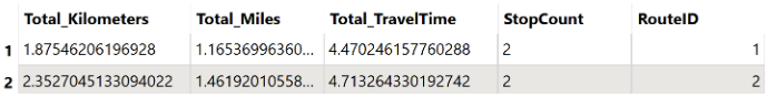
- Routes: provides total kilometers, total miles, total travel time (in minutes), stop count (including the starting point), and route ID.
- Nodes: provide distance to the next node, driving directions, time to the next node (in minutes), route ID, and node ID.
- <Rejected>: Input features are returned via this port if the API call fails. Any error message is stored in the fme_rejection_message attribute.
Routes
Nodes
Final Workspace